Old Maps of Connecticut and
New England |
 |
. |
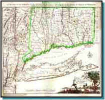
Covens et Mortier et Covens, junior.
Connecticut and parts adjacent. / by Covens and Mortier and
Covens Junior ; H. Klockhoff, sculp. -- Scale [ca. 1:375,000]. --
Amsterdam : Covens and Mortier, 1780.
1 map : col. ; 53 x 59 cm.
Relief shown pictorially.
Shows counties, towns, rivers, and post roads.
Reference: Thompson. Maps of Connecticut, vol. 1, p. 42, no. 28.
Reproduced from the original map in the Geography and Map Division,
Library of Congress. Please contact the Division for copy rights. |
|
|
|
 |
|
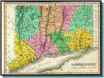
Connecticut / Young & Delleker sc. -- Scale [ca. 1:600,000]; (W 73°40'
--W 71°46'/N 42°10'--N 40°58'). -- Philadelphia : Anthony Finley, 1824.
1 map : col. ; 21 x 28 cm.
Relief shown pictorially.
Hand colored.
Prime meridians: Washington and Greenwich.
From: "A new general atlas, comprising a complete set of maps."
Philadelphia : Anthony Finley, 1824. Plate 12.
|
|
|
|
 |
|
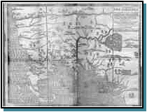
Hubbard, William, 1621 or 2-1704.
A map of New-England, being the first that ever was here cut, and done by the best pattern
that could be had, which being in some places defective, it made the other less
exact: Yet doth it sufficiently show the situation of the country & conveniently well
the distances of places.[S.l. : s.n. , 1677?] |
|
. |
|
For more information about
these and other New England maps click on link - MAGIC |
|
. |
|
|
|